Maps as a social space
Feet, Stealth Startup · Product Designer (Contract)
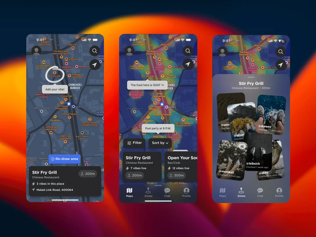
Feet is a hyperlocal discovery app built on an idea we called vibe mapping. You check in at a place through a geofence, see what's happening on a live map, and meet people through chat.
I worked on it as a contract product designer and ran the user research as well as the design: the research, the dynamic map UI, the user journey and the branding. The result was a high-fidelity prototype that turns the map into a real-time social hub.
What it's like there right now
Every map app already tells you what a place is. Reviews tell you what it was like for someone else, months ago. Feet answers a different question: what is it like there right now?
Before designing anything, I surveyed 324 people in Mumbai and Bangalore about how they pick a place to go out. Three numbers came back that the whole product rests on.
- Reviews miss the vibe82%
- Trust on-site posts more94%
Groups also took 28 minutes on average to agree on where to go.
Source: Feet user research, 2025
Twenty-eight minutes is the number I kept coming back to. That's how long a group spends deciding, and it's time nobody enjoys. The research put names on why: too many options (Hick's law), the fear of wasting an evening on a bad pick (loss aversion), and reviews too old to be worth trusting.
Two cities, two people
The cities didn't want the same thing. Mumbai took longer to decide, and its people wanted to discover. Bangalore decided faster, and wanted a plan it could count on.
Tap a persona.
Same map, two jobs. Mumbai reads it for energy, and Bangalore reads it for certainty.
What the research asked for
Each finding turned into a rule for the screens. A heat map instead of a field of icons, because a glance should answer "where is it busy" without reading. One big, always-there button to log your vibe, because the map is only as good as the people adding to it. Five to seven vibe tags at most. And every vibe check stamped with its time and marked as verified on site.
Speed was part of it too. The research set a limit of 400 milliseconds for map data to load, because a live view that lags stops feeling live.
Geofences in real cities
The geofence is what makes "right now" honest. A check-in only counts if you're actually there, which is why 94% trusted it more. But GPS is at its worst in exactly the places Feet cares about: small cafés inside tall buildings, narrow streets and crowded markets. So the radius is a real trade-off. Drag it.
An illustration. Asking people to stay a few minutes before a check-in counts cuts out most passers-by at any radius.
The empty-map problem
A live map is only as good as the number of people on it. On day one in any neighbourhood it's mostly empty, and an empty social map is worse than no map, because it tells you nobody cares about this place.
So the plan launches the core loop first and one city at a time, with a different pitch for each. Social features wait until there's something to be social about.
Tap a phase.
Freshness needs the same care. A check-in from three hours ago shouldn't glow as bright as one from ten minutes ago.
A café changes by the hour and a park by the day, so the fade should depend on the kind of place.
Privacy has to be the default
A map of where people are right now can become a stalking tool if you get it wrong. The defaults have to assume someone with bad intentions is looking at the same map.
That means counts instead of faces until a place has enough people in it, never an exact position, and a way to check in without being visible at all. Chat opens only when both people want it to.
-
The three numbers from the survey of 324 people in Mumbai and Bangalore.
-
What the data says, city by city.
-
Two personas, one per city.
-
What the research told the design to do.
-
The plan: the core loop first, then one city at a time, and social features last.
The brand
The name did most of the branding work. A check-in is a footprint: fresh ones are bright and old ones fade, which is the same idea as the map, so the identity and the product say one thing.
Map opens that end with someone going somewhere
- Vibe checksper person, per week
- Visitsto a place within an hour of viewing it
- Decision timeagainst the 28 minutes from the survey
- Coming backpeople checking in at the same place again
Next bets
Let people ask the map a question. "Where's quiet enough to work right now" can be answered from live check-ins, and no static listing can answer it. The model doesn't need to know much about the city. It only needs to read the live signal and explain its answer.